For once, the government makes something really cool. Topo builder. Custom maps.

100Acre

100Acre

Samsquinch the Terrible Magic Bean Manipulator
Lifetime Member
Club Contributor
Apr 25, 2017
17,441
104,265
113
Idaho
Ownership

  1. 1000-5
So for once in its entire existence, the government finally does something really cool and creates a mapping program where you can create custom 7.5 topographical and down to the detailed quadrangle maps using this new software called topo builder. You can even do hydrologic maps. This is really cool.
 
J

John Mc

Active Member
Lifetime Member
Jan 10, 2023
84
197
33
Vermont
Ownership

  1. 520
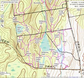
You might want to check out Caltopo (Map the Backcountry with CalTopo) It lets you import and export data from Google Earth or GPS tracks, so you can add property borders, trails and points of interest. Here's a screen shot of an older version I did of my property and trails. You can turn on and off the display of various features (such as the trail names in this screen shot, if things are getting too cluttered.)

The free version still allows you to do quite a bit. The property lines, trails, and blue tint on the wetlands were all things I added.

Screen shot
 
  • Like
Reactions: ChadD